There and back again
5 November 2005
3:27 PM
Friday Roy suggested that we climb one of the nearby mountains. I said it sounded like a good idea. Caitlin suggested that we start at 6:00am. That sounded less like a good idea, but I was still onboard. So, in the madrugada (“early, early morning”) I woke up and left to meet Roy and Caitlin.
The first problem that we encountered is that we didn’t know exactly where to start. “Take us to the mountain,” we told the taxi driver. After some confusion, we ended up in Tunari National Park where we started hiking. Before long we were cursing the Bolivian Parks Department, which is substantially less developed than its U.S. counterpart; there weren’t any trail signs anywhere. We took a couple wrong turns. One lead to an encounter with five territorial dogs. Their owner shouted to us, “There isn’t any trail this way.” We agreed, back-tracked, and found a different trail.
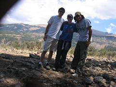
After three hours of ascent, we found a playground with giant slides and teeter-tooters. But no summit. We continued until, after over four hours, we decided to arbitrarily designate our current location as the summit and call it a day. I tied my camera to a tree, set the self-timer, and the result is our “summit picture” shown at the right. Little did we know, the adventure had hardly started.
During our climb, we were continually zigzagging back and forth on switchback roads. To save time on the descent, we decided to cut across the zigzags as a shortcut. In theory and practice it was a good idea. The first two times we cut across the switchbacks and met up with the trail again, saving, I’m sure, oodles of time. But our third shortcut didn’t seem to meet up with the original trail. Before long, we looked over at the mountain next to us and saw our trail. I should add that there was a healthy-sized crevass between our mountain and the mountain we wanted to be on.
We had gone too far to turn back—30 minutes of hiking down a mountain isn’t easily undone, especially if you’re tired. Soon our miniature shortcut trail disappeared and we found ourselves bushwacking down the hillside. “Just think how much time we’re saving,” I reminded a somewhat discouraged Caitlin. Besides, we were going down, which was ultimately the direction we wanted. Finally, we spied a clearing and 20 minutes later we were walking along a legitimate path. It turned out to be a good experience. When we reached the base of the mountain, we walked through a quaint mountain village. We even met up with a mountain goat (I think—I’m no goat expert. Maybe it’s a sheep.). And when we got back to the starting point, we splurged and bought three cold Pepsis for 3 Bolivianos ($0.37).
The total trip took six and a half hours: four and a half up, two down.
Roy has his own account of the trip which you may find entertaining as well. At the very least, he has a picture of us on a giant teeter-totter.


Comments